How US Allies Can Keep An Electronic Eye On China
Posted on

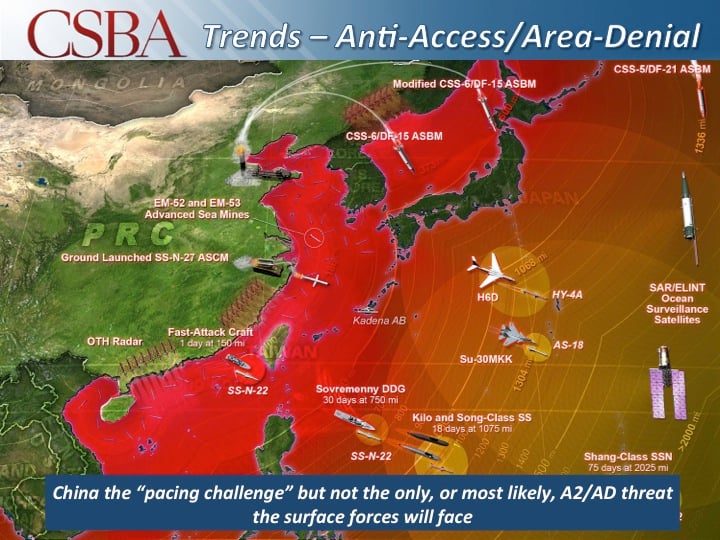
Chinese weapons ranges (CSBA graphic)
As it seeks to contain a rising China, America’s great advantage is its larger network of Asian friends and allies. Not all of these nations have the combat power to deter Chinese aggression, let alone fight alongside the US in the nightmare scenario of war. But even our smaller allies can play a vital role as what President Kennedy called “watchmen on the walls of world freedom” by using radar, drones and long-range networks to monitor Chinese moves.
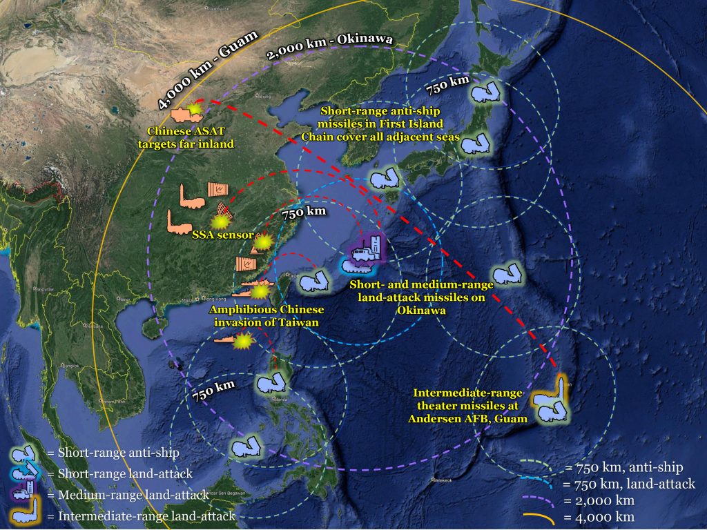
The new Indo-Pacific Strategy released last week marked yet another salvo in the U.S. effort to counter Chinese expansionism and encourage America’s allies and partners to do more in their own defense. Momentum is building behind the argument, advanced by CSBA, the Army, CSBA, and the Marines, that long-range anti-ship, anti-aircraft, and missile defense weapons should be based in First Island Chain countries like Japan and the Philippines to form the dug-in backbone of the allied defense, with air and sea forces forming a mobile reserve.. But these missiles would be beyond the capabilities and the budgets of most Southeast Asian militaries. Instead, the most important contribution these countries can make to regional security is monitoring Chinese activity and protecting communications along what would be the front line of future Chinese aggression.
A reliable surveillance and communications network along the First Island Chain from Japan to Malaysia could warn U.S. and allied leaders of attacks and help them respond in a coordinated fashion. More importantly, having this system in place during peacetime could enable America’s friends in the region to better understand and, perhaps, counter Chinese “gray-zone” tactics such as unlawful island-building and harassment of shipping by Chinese maritime militia ships.
The U.S. government built part of a sensing and communication network during the last two decades, but it fell short of today’s needs. The Integrated Maritime Surveillance System, established by the United States in Malaysia, Indonesia, and the Philippines, installed radars, cameras, and signal detectors around the South China Sea to monitor for piracy, trafficking or terrorism. The United States also transferred retired Coast Guard ships to Southeast Asian governments. Land-based and shipboard sensors, however, generally cannot see over the horizon. They need to be complemented by longer-range airborne or satellite sensors that can operate over the South and East China Seas, the First Island Chain and the Philippine Sea.
The benefit of frequent or continuous surveillance over waters contested by China’s military and paramilitary maritime forces is clear. Less obvious, but just as vital, is the ability of increasingly spread out (“distributed“) U.S. and allied forces at sea and ashore throughout the First Island Chain to talk to each other. In the opening moves of a conflict, the PLA can be expected to jam, disrupt and conduct cyber attacks against the fiber and satellite communication networks these forces depend on. New low-cost, jam-resistant communications systems could maintain contact between U.S. and allied ships, troops, aircraft and unmanned systems and demonstrate to Chinese leaders that an act of aggression is unlikely to rapidly succeed.

A notional network of land-based long-range missile batteries in the “First Island Chain” to contain China. (CSBA graphic; click to expand)
Competing for the long-term
The U.S. Defense Department is already developing parts of what could be the space component of a resilient Indo-Pacific surveillance and communications network. The DARPA Blackjack program, Air Force Space Sensor Layer, and other proliferated low earth orbit, or LEO, satellite constellations offer the potential to maintain near continuous monitoring and radio contact over the region for as low as $6 million per satellite. Allies could partner with the U.S. in securing access to some of these satellites or purchase access from commercial providers. But LEO satellites move quickly around the earth and only spend a few minutes every hour or so above the area around the First Island Chain. They also largely move on known orbits and are susceptible to jamming or attack.
To complement space systems, the U.S. and allies should also regularly deploy drones and balloons from the First Island Chain. Japan and Australia are buying high altitude RQ-4 Global Hawk and MQ-4 Triton drones from the United States, which can search and relay communications over hundreds of square miles. But R/MQ-4s could be too expensive for America’s Southeast Asian allies and partners, and they will likely be focused on strategic missions like watching North Korean missile operations.
Smaller, less expensive drones like the MQ-9 Reaper would be well-suited to keeping an eye on Chinese military and militia activity in peacetime, targeting Chinese military forces in conflict, and sustaining U.S. and allied radio links in the face of Chinese jamming. Within the First Island Chain, Japan is collaborating with the United States on an MQ-9 demonstration, but is not yet buying any Reapers. MQ-9s are also becoming easier for smaller militaries like those in Southeast Asia to employ; several NATO allies are purchasing and operating Reapers, and the increasing automation of the MQ-9 could eliminate the need for it to be remotely piloted from the ground. Sales of Reapers and other large drones are only allowed to a small number of countries under the Foreign Military Sales process, but the Trump administration recently began allowing Direct Commercial Sale of these systems. Even if sales to Southeast Asian militaries are not possible, the U.S. military could deploy and operate MQ-9 and similar drones from the First Island Chain.
Unmanned aircraft could be augmented by simple, inexpensive high-altitude balloons like those being launched by Google as part of its Loon program, which is providing broadband Internet to remote areas. Launched locally and managed remotely by satellite communications, groups of balloons can maintain an orbit over the desired area for weeks to months at altitudes of 60,000 to 100,000 feet, enabling them to see and communicate up to 300 miles away.
Implementing the new Indo-Pacific Strategy requires a robust communications and surveillance network in the Western Pacific, particularly along the First Island Chain. Without such a system, the United States and its allies may miss opportunities to stop or slow China’s gray-zone aggression, or could be flying blind in the early stages of a conflict. Sustaining this network for what could be a decades-long competition will require a cost effective approach. The emerging generation of low-altitude satellites, coupled with affordable drones and high-altitude balloons, could be a solution for America’s Indo-Pacific allies and partners.
Subscribe to our newsletter
Promotions, new products and sales. Directly to your inbox.
